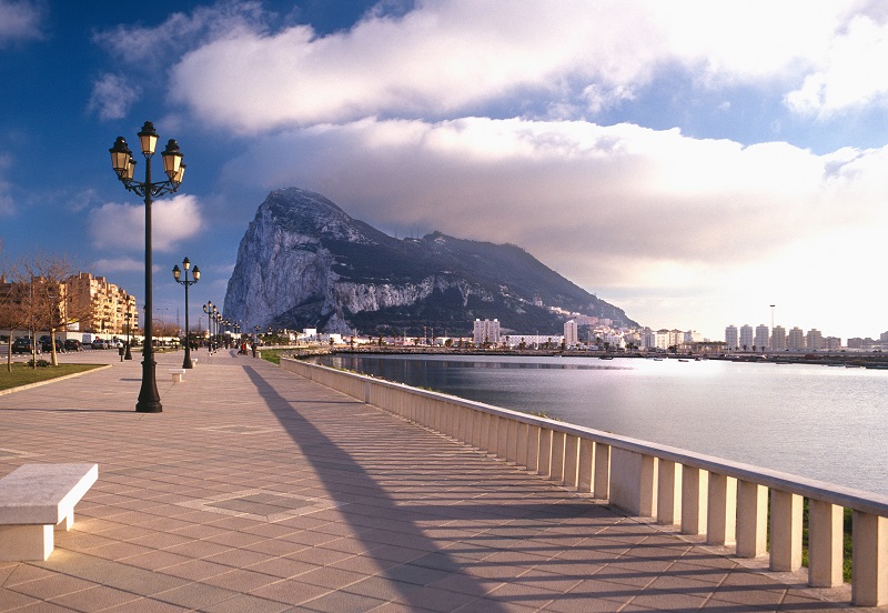
Until the discovery of the Americas in the West, the common notion was that Europe formed the edge of the world. Apart from the northern Scandinavian nations and the southern African countries, there was a single geographic accident that also marked the limit. It was about the Rock of Gibraltar, also known as the Columns of Hercules.
Included in Greek mythology, the stretch that flows around the Rock has played an important role in human civilization since before 500 BC. Considered as one of the most traveled waterways in the world, it has a direct impact on world trade. The stretch connects the Atlantic Ocean to the west with the Mediterranean sea to the east. But all over the ocean is the American continent, while the sea has numerous nations on its coast.
Morocco, to the south, and Spain, to the north, surrounding the main part of the stretch. In addition to being an important maritime and commercial route, the stretch has much to offer. There are numerous interesting stories related to its long history. There are tourist places and famous places, such as the imposing headland of the Rock of Gibraltar, which stands out from meters from the ground. In this article, we have a look at the most interesting facts about the stretch of Gibraltar. From its extraneous etymology to its geographical and economic importance, this is your guide to everything related to the Strait of Gibraltar.
The word «Gibraltar» comes from the Arabic phrase «Jabal al Tariq»
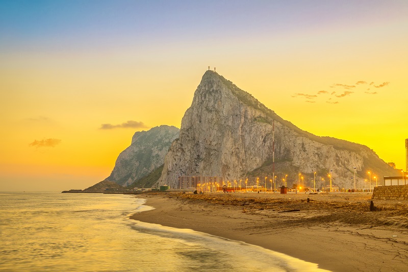
One of the most outstanding features around the stretch of Gibraltar is the big rock that stands out in the aire. With more than 460 meters of height, it is the characteristic of the land that comes from the name of Gibraltar. In Arabic, the word «Jabal» or «Jebel» means mountain. Tariq makes reference to a Berber commander from North Africa who, on one occasion, led a great military expedition in the stretch. The commander -Tariq ibn Ziyad- crossed the stretch to the headland at the beginning of the VIII century AD, and since then it has been known as «Jabal al Tariq» or the «Montaña de Tariq».
Gibraltar is the Spanish derivation of the Arabic phrase, given that the region is close to the Spanish mainland. The ruler of Ceuta, which is now an autonomous Spanish territory, had arranged that the Berber army had crossed from its North African kingdoms to Spain. A large fleet of vessels was used to transport them, and this marks one of the first crosses of the stretch of them that is confirmed. When they landed on the coast, they were consolidated at the foot of the gran roca, which was baptized in honor of the commander who had led them there. Tariq and another Berber leader, Musa ibn Nusayr, later captured a large part of Spain with 20,000 soldiers. The port of Tarifa, west of Gibraltar, bears the name of Tariq ibn Ziyad, bell of another Muslim leader called Tarif who landed on the coast several years before.
Despite being close to Spain, Gibraltar is a British territory
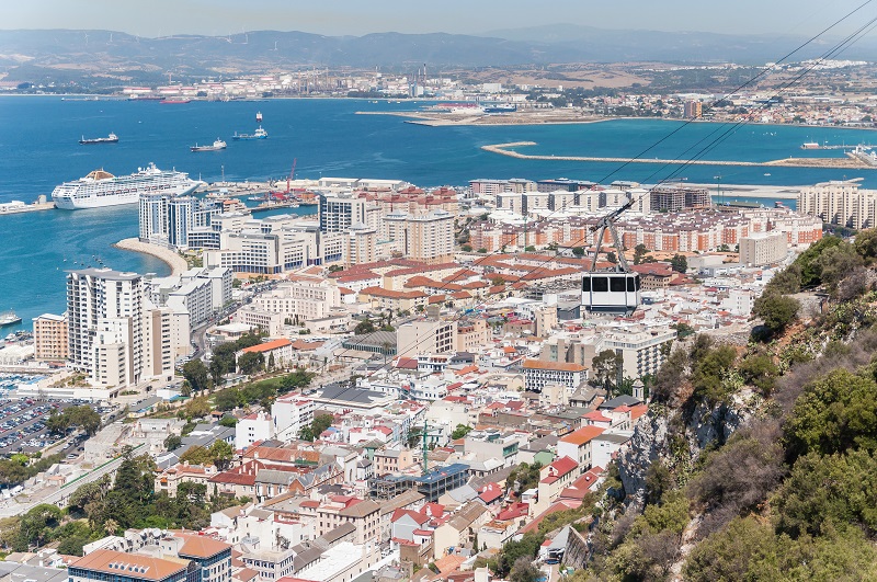
When looking at a map of Gibraltar, it is easy to confuse it with a Spanish city. However, Gibraltar is actually a special overseas territory of Great Britain. Once it formed part of Spain, it was ceded to Great Britain after the War of Succession Española. A peace treaty signed in the Dutch city of Utrecht (known as the Treaty of Utrecht) granted Great Britain the permanent rights to rule Gibraltar. However, there have been numerous attempts on the part of the Spanish to recover the region, including armed conquests in the 18th and 19th centuries.
Spain has maintained that it wants to reunify Gibraltar with the rest of the peninsula and has set up the questioning before the United Nations on repeated occasions in recent times. However, Great Britain has constantly refuted the Spanish pretensions. In Gibraltar, numerous referendums and public votes were held so that citizens themselves chose the country they wanted to join. The majority of votes were in favor of the stay in Great Britain, and the last referendum was 98% in favor of the stay.
Today, the questioning has taken on greater relevance with the growing importance in commerce, los ingresos y las rentas, and the military importance of the stretch. The UN recognizes Gibraltar as an autonomous territory. The stagnation has continued for the previous three centuries, although there have been no armed skirmishes in the last few times. According to the position of Great Britain in this matter and the international maritime law, Great Britain cannot directly control the passage of boats through the stretch, unless there is illegal transport of contraband. Although it is used legally, there is no restriction on the use of the stretches by other countries, armed or commercial ships.
The Rock of Gibraltar and a peak of North Africa form together the «Pillars of Hercules»
Gibraltar is crossed by the mythical Columns of Hercules, in reference to the mythical Greek hero Hercules. The myth says that during the 12 works, Hercules crossed Mount Atlas to create the stretch. The pillar of the European coast is the Rock of Gibraltar, while the pillar opposite continues to be a matter of dispute. The Gibraltar rock is known as Calpe Mons, while the opposite peak is known as Abila Mons. There are two main hills that have historically been considered the second pillar: Monte Hacho (in Ceuta) and Jebel Musa (Morocco). The area is also special for the Greeks, who considered it to be the place where the Titan Atlas carried the weight of the sky on his shoulders. When Hercules crossed, it is said that he inscribed on the pillars «Non-Plus Ultra», which means «nothing but allá». The Spanish shield carries this inscription, although it has now been changed to «Plus Ultra» after the discovery of the Americas. It has had importance in Greek mythology, as the Greeks offered their prayers to Hercules here. The Rock is also a famous tourist destination, with many people coming to Gibraltar for all it has to offer.
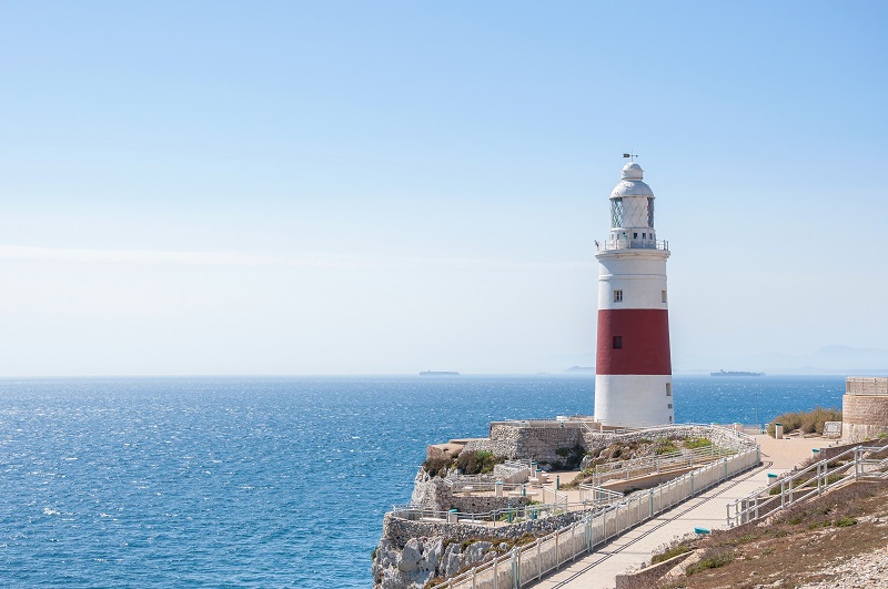
Gibraltar is famous for the «Punta de Europa»
The waters of the Mediterranean Sea and the Atlantic Ocean cannot be more different. The sea has a very high saline content, while the ocean has a softer environment for different creatures to survive. The exact point where these two water masses converge is known as «Punta de Europa». Europe is the southernmost point of the Iberian Peninsula and is located in Gibraltar. Another point, Punta de Tarifa, is located further west and parallel to Punta de Europa.
The area is a famous tourist spot, with outstanding buildings such as the Harding Battery, the Ibrahim-al-Ibrahim Mezquita, the Faro de Europa and the Sikorski Monument. Harding’s Battery was a British fortification built in the 19th century that could launch missiles across the stretch. The Ibrahim mosque was built as a gift to the king of Arabia Saudi -Señor Fahd bin Abdulaziz Al Saud- in 1997. It serves the diverse Muslims of the region. The Faro de Europa is a famous place from where you can see Morocco on a clear day. Finally, the Sikorski Memorial was built to commemorate the victims of the B-24 accident that took place in the life of Commander Wladyslaw Sikorski (Polish Prime Minister in exile) when he crashed in Gibraltar.
Gibraltar has an underground labyrinth that has participated in great wars
Gibraltar has been the scene of innumerable wars since the II century of our era. Since the Berber invasions that entered the zone under its singular name, until the numerous Spanish attempts to return Gibraltar to its domain, the zone has played an important role in the battle. One of the main reasons is the location of the stretch. It is a step between the Atlantic Ocean and the Mediterranean Sea, one of the most popular maritime routes in the world. For this reason, the nation that has control of Gibraltar can block and prevent navigation in the event of war. The current laws of the British government allow any boat to navigate as long as it is registered, not carry illegal cargo without passing and follow the rules of the sea.
The land battles for the conquest of Gibraltar had left numerous lasting elements in the area. From the Harding Battery in Punta de Europa to a labyrinth of tunnels below the surface, there are several attractions for history buffs. These tunnels were built during the American War of Independence by the British. When the French and Spanish troops attacked the surroundings, the British launched their long-range cannons in the south. This led to the formation of a series of tunnels that could be used to transport messages and troops secretly and safely across the island. Today, visitors to the island can tour most of the tunnel sections that are open to view.


